Upcoming Exhibitions
Oblique Views: Archaeology, Photography, and Time
Oct 25, 2015 — May 7, 2017
For the first time in Oblique Views: Archaeology, Photography, and Time, large prints of Heisey’s stunning images will be paired directly with the Lindberghs’. The exhibition opens October 25, 2015 and runs through May 7, 2017 at the Museum of Indian Arts and Culture.
During 2007 and 2008, flying at alarmingly low altitudes and slow speeds, Adriel Heisey leaned out the door of his light plane, and holding his camera with both hands, re-photographed some of the Southwest’s most significant archaeological sites that Charles Lindbergh and his new bride Anne photographed in 1929.
Galisteo
Galisteo is now considered statistically part of the Santa Fe metropolitan area, although it is still remote and has a population of less than three hundred people. It is home to a number of well-known artists and scholars, as well as families traditionally linked to the area, none of whom farm on the scale of the past. Galisteo Creek no longer washes away vegetation in the streambed, which now appears to be a lush forested strip. The church and cemeteries remain, as does the layout of the colonial village. Traces of the old narrow fields can still be seen. Photograph by Adriel Heisey, 2015.
Santa Fe
While still not large, Santa Fe has grown remarkably since 1929. Houses cover the areas that were once farmed, and flat roofs around the Plaza dominate the scene. The Palace of the Governors (now backed by the New Mexico History Museum), the New Mexico Museum of Art, the cathedral, and other beloved buildings are still in use. The Roundhouse has replaced the old capitol building, which was remodeled and converted to administrative use. The river still flows through Santa Fe, at least seasonally, but it is less visible among the sea of buildings that engulf it. A few solar panels show environmental investment by individuals. Photograph by Adriel Heisey, 2015.
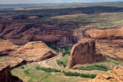
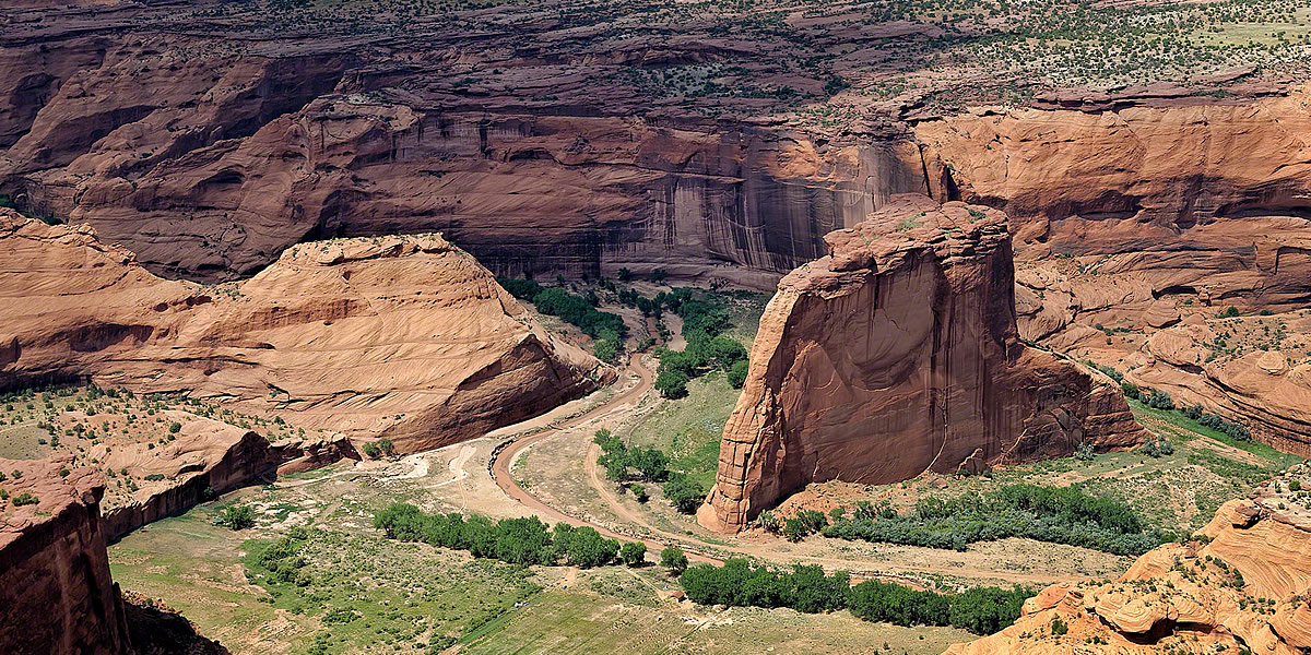
White House
White House is harder to see now because of the additional vegetation. This is the only site in Canyon de Chelly that is accessible without a guide and is by far the most visited ruin in the canyon. A hiking trail leads to the site from a parking lot on the rim above. A pedestrian bridge over the wash can be seen, as can the hiking trail. Tour trucks and jeeps park at the ruin-end of the bridge, although they ford the wash rather than crossing the bridge. Even outside the wash, plant growth is lusher today, in part because the site is not being grazed as intensively as it was in 1929. Photograph by Adriel Heisey, 2008.
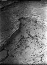
Pueblo del Arroyo
Pueblo del Arroyo lies immediately next to Chaco Wash, and its location inspired its name. When the Lindberghs photographed the site, the circular tri-walled structure on the western extension of the pueblo was being eroded by the wash. Neil Judd excavated a large part of the pueblo in the late 1920s, resulting in the empty rooms visible in both photos. The more modern buildings to the southeast of the ancient pueblo were built by Richard Wetherill in 1899 and served as a boarding house for archaeologists and other visitors. They were converted into the Chaco Canyon Trading Post in the 1930s. The road to Gallup crossed the wash nearby. Photograph by Charles A. and Anne Morrow Lindbergh, 1929.